For more information on the topic of Noah’s ark please check out the Answers in Genesis resource page here.
Is the Wood Recently Found on Mt. Ararat from the Ark?

One of the photos released by the discovery team of the inside of the wooden structure claimed to be part of the remains of the Ark which they found on Mt. Ararat.
Exposing a False Claim of Finding Noah’s Ark

HOAX: NAMI fake ark “discovery” on Mount Ararat a scam!
The Noah’s Ark Discovery Fraud... Exposed

Dr. Don Patton Exposes Wood Fraud (September 2010)
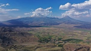
Is Noah’s Ark on Mount Ararat?

Deep under Mount Ararat are thousands of feet of Flood sediments, filled primarily with marine fossils from the destruction of life in the ocean and on land. These are similar to Flood layers we find all over the earth.
Ark found on Mount Ararat? Or is it a scam?

Did Noah’s ark land on Mount Ararat? If it didn’t why do we have all these eyewitness sightings of the boat up there? Does the geology of the mountain help us in our quest to find the location of Noah’s ark?
Noah’s Ark ‘Discovery’ Likely a Sinking Ship (ICR)

According to personal correspondence with other serious Ark searchers, investigations of the 2010 NAMI claims concluded that they were fake.
Four Reasons for Rejecting Mount Ararat (Ağrı Dağı) as Noah’s Ark’s Final Resting Place*
- The early ancient sources do not mention Mount Ararat (Ağrı Dağı) as the landing site of Noah’s Ark.
- Mount Ararat (Ağrı Dağı) is a volcanic mountain (composite/stratovolcano) and was never submerged underwater, and thus it was formed after the Flood and could not be the landing site of the Ark.
- The “eye-witness” accounts are unreliable and most don’t agree with each other.
- Thus far, after around 70 years of searching, nothing has ever been found there even after the glacier on top of the mountain has retreated since the 1970s.
*Inspiration for this list from a Bill Crouse paper given at the “International Noah and Judi Mountain” symposium held in Sirnak, Turkey on Sept. 29, 2013. Click to watch a recording of his talk.
The Ark Landed West of Mt. Ararat (ICR) (Another claim for the location of Noah’s ark)

Google Earth image of the area around Mt. Ararat, including Kagizman Ridge. The line of the section depicted in Figure 2 is shown.
International Mount Ararat And Noah’s Ark Symposiums

Agri Dagi ve Nuhun Gemisi Seopozyumu. International Mount Ararat And Noah’s Ark Symposium
- The Fourth International Mount Ararat and Noah’s Ark Symposium: 18t-20 October 20l7
- The Fifth International Mount Ararat and Noah’s Ark Symposium: 16-18 October 2019
- The Sixth International Mount Ararat and Noah’s Ark Symposium: 26-27 October 2021
- The Seventh International Symposium on Mount Ararat and Noah’s Ark: 19-21 October 2023 Abstract
Scientific papers and news articles about Mount Ararat and eastern Turkey
-
- Ağrı İbrahim Çeçen University, Faculty of Arts and Sciences, Department of Geography faculty member Prof. Dr. Faruk Kaya said that the skullcap glacier on the summit of Mount Ararat is rapidly melting every year due to global warming and climate change, and that if the current melting rate continues, nearly half of the glacier could disappear by the 2050s.
-
- “AĞRI (İHA) – Ağrı İbrahim Çeçen University, Faculty of Arts and Sciences, Department of Geography faculty member Prof. Dr. Faruk Kaya stated in his statement that Mount Ararat, Turkey’s highest peak at 5,137 meters, is known not only for its majesty but also for the skullcap glacier covering its summit.
Emphasizing that the Takke glacier has natural, cultural, and symbolic value for both the scientific world and the local people, Kaya said, “The rapid shrinkage experienced in the last century, especially in the last 50 years, has made the future of this unique structure uncertain.”
Glacier area halved in 50 years
Kaya stated that scientific studies and satellite images clearly reveal the change in the size of the skullcap glacier, adding that the glacier area, which was approximately 70 square kilometers millions of years ago, shrank to 15 square kilometers in the early 1900s and to 9-10 square kilometers in the 1970s.
Kaya explained that between 1976 and 2011, the area shrank by an average of 0.07 square kilometers per year, decreasing by approximately 29 percent during this period. The rate of shrinkage accelerated between 1977 and 2024, reaching an average of 0.095 square kilometers per year. Noting that the current glacier area has shrunk to 4.5-5 square kilometers, Kaya said, “These figures represent a decrease of approximately half the glacier area over the last 50 years.”
Half of the glacier could disappear by the 2050s.” - https://haber49.net/agri-dagi-takke-buzulu-hizla-eriyor-2050ye-kadar-yariya-yakini-kaybolabilir
- “AĞRI (İHA) – Ağrı İbrahim Çeçen University, Faculty of Arts and Sciences, Department of Geography faculty member Prof. Dr. Faruk Kaya stated in his statement that Mount Ararat, Turkey’s highest peak at 5,137 meters, is known not only for its majesty but also for the skullcap glacier covering its summit.
- Large-volume lava flows fed by a deep magmatic reservoir at Ağrı Dağı (Ararat) volcano, Eastern Turkey (Bulletin of Volcanology 79(2), February 2017)
-

The last basaltic/most basaltic lava flows around Ağrı Dağı volcano. a, b Google Earth images of basaltic lava flows at around the Great and Lesser Ağrı Dağı volcanoes. c, d Images of the most recent lava flows (I–II)
- “Ağrı Dağı (Ararat), whilst being the tallest volcano in Turkey, is largely understudied. Two predominant peaks, Greater and Lesser Ağrı, make up the main edifice, which has been built during four main phases. The most recent phase consisted of two volcanic eruptions. The respective surface area and volume of the first volcanic eruption were estimated at 96 km2 and 3.2 km3, whereas those of the second eruption were much smaller with the surface area and volume estimated at 25 km2 and 0.6 km3. It is unusual for stratovolcanoes to produce basaltic eruptions of more than 3 km3, although these and larger volumes are not uncommon in flood basalt-type eruptions. Large basaltic eruptions from stratovolcanoes normally require volcano-tectonic forcing (e.g. subsidence of collapse caldera and graben). However, there is no evidence for such volcano-tectonic forcing, during the most recent eruptions at Ağrı Dağı (Ararat), and therefore, their comparatively large volume basaltic lavas need to be explained in a different way. Here, we present an analytical method for calculating the source volume needed to supply magma to the eruptions at Ağrı Dağı.”
-
- Geomorphological effects of the 1840 Ahora Gorge catastrophe on Mount Ararat (Eastern Turkey) (Geomorphology Volume 332, Pages 10-21, 1 May 2019)
-

Geographical position of Mount Ararat study area from a Sentinel 2 image acquired on July 21, 2017.
- “According to our interpretation, an earthquake in 1840 triggered an abrupt volcanic eruption, which caused the consequent rapid melting of glacial ice and mountain snow. This event produced significant mud and ice flow along the Ahora Gorge that inundated the villages downslope. The flooding, which we interpret as a lahar, deposited a wide alluvial fan at the foot of the volcano. Today, an elongated landform present within the Ahora Gorge has alternately been interpreted as a landslide deposit.”
-
- Glacier loss on Mount Agri (Ararat) and its climatic significance (Quaternary International 279-280:427, November 2012)
-

Digitized outlines of Mount Ağrı Ice Cap from (A) 1976 Landsat MSS, (B) 1984 Landsat TM, (C) 1989 Landsat TM, (D) 2000 Landsat ETM+, (E) 2002 ASTER and (F) 2011 ASTER imagery. For the Landsat images false-color composite (RGB = Bands432) were presented. 2000 ASTER image is the band ratio of ASTER3/ASTER4. 2011 image is also a false-color composite (RGB = Bands321). Calculated planimetric areas and 10% digitization error of the ice cap are given on the lower right corners of the images. Topographic contour intervals in (F) are in every 250 m.
- “Glacier recession reports in response to sustained climatic warming are widespread. However, little information exists on glacier behaviors from the Middle East where a few ice bodies still exist. Here, an ice cap retreat from Mount Ag˘rı (also known as Ararat, 39.70°N, 44.30°E, 5137 m), Turkey, based on satellite measurements since 1976 were given. The results show that the ice cap has lost 29% of its surface area at a rate of -0.07 km2a-1. The long-term atmospheric warming trend observed at the nearby meteorological stations is consistent with this shrinking trend.”
-
- 35-million-year-old sea creature fossils found in eastern Turkey (Daily Sabah, August 16, 2021)
-

Fossils unearthed at Muş, eastern Turkey, on Aug. 14, 2021. (IHA Photo)
- “We’ll have new data and new information about the paleogeography and paleoclimatic conditions of Muş, especially in the geography of the region,” he said, underlining that the information about these fossils could help reinterpret, the regional geography of eastern Anatolia.He noted that fossils, which were found at an altitude of 1,600 meters (5,250 feet), “naturally indicate that this place was once a sea.”
-
- The summit of Mount Ararat is melting (English translation)
-

Mount Ararat glaciers are melting.
- “The glacier-covered summit of Mount Ararat, which is the highest mountain in Turkey with an altitude of 5,137 meters, between Doğubayazıt district of Ağrı and Iğdır, on the border of Iran and Armenia, is melting day by day…‘I am a professional mountaineer and mountain guide. I have been climbing Mount Ararat for 23 years. I participated in over 200 activities. The drastic change in Mount Ararat in these last 23 years is really frightening because the glaciers are melting incredibly fast. Especially in the last 10 years, the valley called ‘Ox Creek’ was covered with glaciers, but now it has completely melted. When the ice melted, the lands below emerged, and the melting continues very quickly. There are 4 climbing routes to Mount Ararat. In 15 years, there has been a melting between 70 and 100 meters depending on the direction on these routes. From time to time, it causes flooding in residential areas under the mountain due to melting. Global warming is indeed frightening. Everyone should take responsibility and find a solution to this. I think this generation will see the glaciers end.'”
-
- EXCLUSIVE: Satellite Sleuth Closes in on Noah’s Ark Mystery
-

DigitalGlobe’s QuickBird commercial remote sensing satellite imaged the Mt. Ararat “anomaly” in 2003. This image has never seen by the public until now. The anomaly is surrounded below by very rugged-looking strato-volcanic rock; however, the texture of the feature in question is relatively smooth and appears to be made of a different substance. (Image credit: DigitalGlobe)
- “High on Mt. Ararat in eastern Turkey, there is a baffling mountainside “anomaly,” a feature that one researcher claims may be something of biblical proportions.Images taken by aircraft, intelligence-gathering satellites and commercial remote-sensing spacecraft are fueling an intensive study of the intriguing oddity. But whether the anomaly is some geological quirk of nature, playful shadows, a human-made structure of some sort, or simply nothing at all-that remains to be seen.”
-
- Genesis of collision volcanism in Eastern Anatolia, Turkey

Distribution and tectonic setting of the late Miocene to Recent volcanics of the Eurasia – Arabia Collision Zone.
- “Late Cenozoic volcanism in Eastern Anatolia extends in a broad SW – NE trending belt across the Arabia – Eurasia collision zone, from the Arabian foreland basin in the southwest and to the Kars Plateau and Lesser Caucasus in the northeast. Foreland volcanism is dominated by basaltic shield and fissure eruptions of transitional tholeiitic – alkaline composition. Volcanism on the thickened crust north of the Bitlis Thrust Zone varies from the mildly alkaline volcano, Nemrut, and older Mus volcanics in the south, through the transitional calc-alkaline/alkaline volcanoes Bingöl and Süphan and the alkaline volcano Tendürek to the calc-alkaline volcano Ararat and older Kars plateau volcanics in the north.”
-